Posts

Featured Post

Mountains Of India - Nun Kun

Image
Nun Kun is a mountain massif (Massif) standing in the Union Territory of Ladakh, India. This massif has two peaks - 7,135 m (23,409 ft) high Nun Parvat and just north of it is 7,077 m (23,218 ft) high Kun mountain. There is a snow-covered plateau 4 km long between the two peaks. This massif is near Suru valley of Kargil district and is bordered by the Union Territory of Jammu and Kashmir. Nun Kun is 250 km east of Srinagar. To the north of Nun Kun Punjak lies Suru valley and Zanskar ranges. To the east is Suru Valley and 4400 meters high Pensi La (Pass), which separates it from Zanskar Valley. To the south is the Kishtwar National Reserve and the Crush Nai River. To the southwest and south is a collection of glaciers, mountains, and rivers that cross the Kashmir valley, Kishtwar and Doda. There is also a third peak of the summit near Nun Kun, the 6,930 m (22,736 ft) high Pinnacle mountain.
Mountains Of India - Agasthyarkoodam

Image
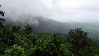
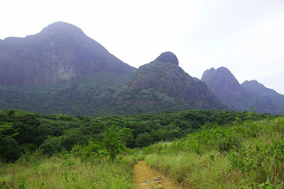
Agasthyarkoodam has an 1,868-meter (6,129 ft) -tall peak in the Western Ghats of South India.It is a part of the peak Agastyamala Biosphere Reserve which lies between the border states of Kerala in Kerala (in Pathanamthitta, Kollam and Thiruvananthapuram districts) and Tamil Nadu (in Kanyakumari district, Tirunelveli district). The perennial Thamibarani River originates from the eastern side of the range and flows into the Tirunelveli district of Tamil Nadu. Agastyakumaram is the pilgrimage center for the devotees of the Hindu sage Agastya, who is considered one of the seven Hindu Puranas of the sages (Saptarishi). In Tamil traditions, Agastya is considered the father of the Tamil language and the compiler of the first Tamil grammar called Agattayam or Akatiyam and is also believed to have originated from the Malayalam language Agastya. There is a small stone idol of Agathiyar on the top of the peak and devotees can offer worship to themselves. Agastyamala Biosphere Reserve is one of 2

Mountains Of India - Guru Shikhar

Image
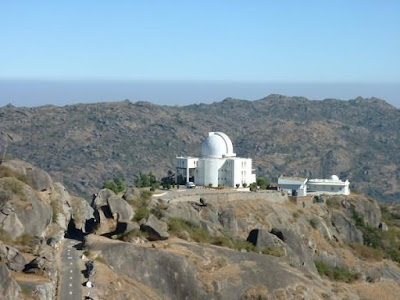
Guru Shikhar Peak is the highest peak in the Aravalli region, 15 km from Mount Abu. Is located at a distance. It is situated at an altitude of 1722 meters. Tourists go on foot to this magnificent splendid peak. Travelers can have a complete view of the Aravalli region from the top of the mountain. Guru Dattatreya Temple is an ancient temple situated on the top of this mountain. This temple is dedicated to Lord Dattatraya who is considered to be the incarnation of the divine Trinity Lord Brahma, Lord Vishnu and Lord Shiva. Other temples on this mountain are Shiva Temple, Meera Temple and Chamundi Temple. Apart from these temples, there is also an observatory from where land based infrared observations of celestial bodies can be made. The observatory is under the administration of the Physical Research Laboratory (PRL). If you are going to visit Guru Shikhar, then walking in the morning for you can prove to be quite good for two reasons. The first is the breathtaking sunrise view and the

Mountains Of India - Ayodhya Hills

Image
Ayodhya Hills is a hill in Purulia district in the Indian state of West Bengal. It is a part of Dalma Hills and an extended part of Purbaghat Mountains. Gorgaburu is the highest peak of the Ayodhya hills. Baghmundi is a town near this hill. The nearest railway station is Balrampur. Ayodhya is a popular destination for mountaineering students. There are two ways to go to Ayodhya hills. One becomes Jhalda and the other becomes Sikrabad. There is also a forest rest house here. Gorgaburu (755 m), Mayuri etc. are some of the peaks of Ayodhya hills.This region is the lowest step of the Chhota Nagpur Plateau. The area around Baghmundi or Ayodhya hills is an extended plateau. According to Hindu legend, Rama and Sita came to the Ayodhya hills during the Banas. When Sita came here and was thirsty, Rama dug the ground with his arrow and fetched water. That place is known as Sitakunda. On the full moon day of the month of Baishakh, the local tribes join the wildlife hunting festival here. From Ayo

Mountains Of India - Shaktiman

Image
This mountain is one of the Saptakul mountains of ancient India. The name of this mountain is Shakti Parbat, which extends from Raigad city of Chhattisgarh to Dalma Parvat in Bihar. It has gone from the south of Vindhyachal mountain to the far east, cutting from the middle. That is, this mountain is a mountain in the eastern part of Vindhyachal, from which the Rishikulya river flows into Orissa and falls in the 'Bay of Bengal'. Shuktimaan mountain is associated with the river named 'Shuktimati'. The river named Shuktmati flows near 'Shuktmati', the capital of the Chedi country of the Mahabharata period. According to historians, the Shuktmati river is the Ken river flowing near Banda (Uttar Pradesh). There are many other rivers named Ken. Many industrial cities have developed around this mountain range, due to which the existence of mountains and the rivers originating from it is in danger. Legendary places and industrial cities are inhabited by Hirakud, Sundarga

Mountains Of India - Mahendragiri And Mahindrachal

Image
This mountain is one of the Saptakul mountains of ancient India. Mahendragiri and Mahindrachal are considered two in India. One on the Eastern Ghats and one on the Western Ghats. The Mahendragiri of Valmiki Ramayana is on the Western Ghats, from where Hanumanji jumped to Lanka. The other is Mahendragiri, described in the Puranas. The second is to the north of the Eastern Ghats and extends to the central part of Orissa. Mahendragiri is a mountain range extending from Orissa to Madurai district. It also includes the hills of the Eastern Ghats and the mountain ranges extending up to Gondwana. It is believed that after destroying the Haihayavanshi Kshatriya, Parashurama donated the earth containing the Saptadwip to Maharishi Kashyapa, then he gave up his weapons and weapons before Devaraj Indra and lived in the ashram on the 'Mahendra Parvat', the terrain which was cited by Sagar. Started. They still live there today. According to the Puranas, taking a bath in the Parashurama pilgr

Mountains Of India - Aravalli

Image
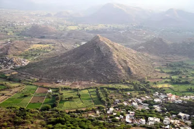
Aravalli is a mountain range located in the western part of India, Rajasthan. Also known as Adavala mountain in Rajasthan, Aravalli is the oldest mountain range in the geographical structure of India, which is the existence of Godwana land. It is the oldest mountain range in the world, which divides Rajasthan from north to south in two parts. It originated in the Precambian era (4.5 million million years). The highest mountain peak of Aravali is Gurushkhat (1722/1727 m) in Sirohi district, which is in Mount Abu (Sirohi). The Bhil tribe has lived in the vicinity of the Aravalli ranges for centuries. The estimated age of the Aravalli mountain range is 570 million years. This is an example of a residual mountain with a total length of about 692 km from Gujarat to Delhi, about 79.49% of the Aravali mountain range is in Rajasthan, Rashtrapati Bhavan located in Delhi on the Raisina hill. It is a part of the Aravalli mountain range, the average elevation of Aravalli is 930 meters (1000 meters